Top

To the cave dwelling "Mortner Gufl"

Steinegg
Add to favourites
Difficulty
Easy
Activity time
1:41
Duration in hours
Distance
5.7
Distance in km
Suggested period
Jan
Feb
Mar
Apr
May
Jun
Jul
Aug
Sep
Oct
Nov
Dec
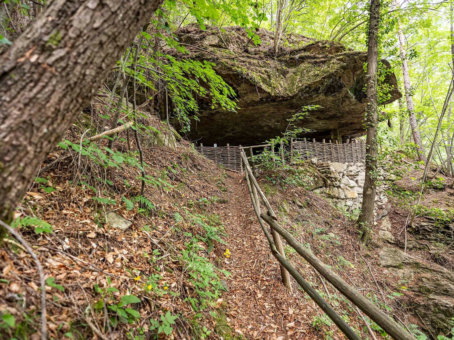
Hike to a cave dwelling with a special history near Steinegg|Collepietra.
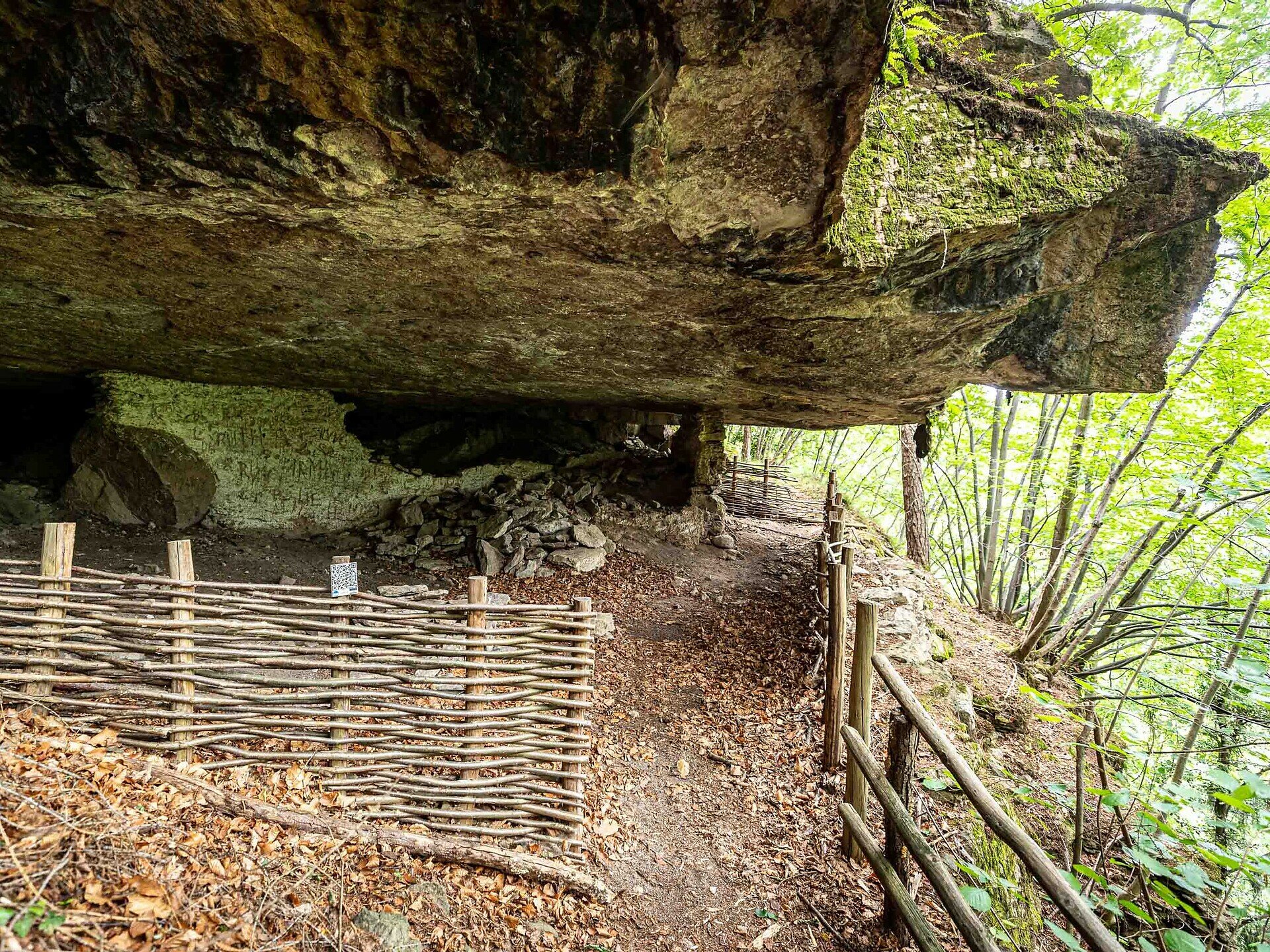
The cave dwelling "Mortner Gufl" is located on the old carriage road, which at that time connected Steinegg|Collepietra with Kardaun|Cardano and Bozen|Bolzano.  About 500 m from the farm Mortner in the direction of Kardaun|Cardano, there is an extensive, flat square with a thick stone slab hanging over it, as if it wanted to provide a protective roof for the little place. It is said that a hermit, the "Mortner Hias", lived here during the First World War. He even set up a farm oven in this natural dwelling and walled the place up. The hermit wove baskets here. During the Second World War, this place was used as an air-raid shelter for the inhabitants of the nearby farm Mortner. Some remains of the wall can still be discovered and admired today.
In 1951, there is also said to have been an apparition of the Virgin Mary at this special place.
A descriptive board on site tells of these extraordinary occurrences at the cave dwelling "Mortner Gufl".

Important note: There are no refreshment stops along the entire route. However, at the start and end point in Steinegg|Collepietra, you will find several restaurants, cafés, and two shops.
Route info
Easy
Distance
5,7 km
Activity time
1 h 41 min
Ascent
215 m
Descent
216 m
Physical effort
Scenary
Highest point
820 m
Lowest point
624 m
Directions
From the car park at Cafè Christl, walk past the Lex Market grocery shop along hiking trail [2] / Rittersteig. Continue along the Rittersteig past the Ebenhof farm until you reach the turnoff to the Mortner farm. Here you walk a short distance in the direction of Mortner farm and then immediately turn left to Mortner Gufl. Always follow the hiking trail [2].
The way back is via the same path.
public transportation

Getting to the starting point of the tour by public transport is easy and convenient.

By public bus line
- 182 from Bozen | Bolzano
- 187 from Welschnofen | Nova Levante
- 180 from Karersee | Lago di Carezza, Karerpass | Passo Costalunga, Val di Fassa*
- 184 from Oberggen, Eggen | Ega*
- 181 from Weissenstein | Pietralba, Petersberg | Monte San Pietro, Deutschnofen | Nova Ponente, Stenk*
- 187 or 182 from Gummer | San Valentino in Campo
*change in Birchabruck | Ponte Nova to the line 182

Bus stop: Steinegg | Collepietra Village;
online timetable search at South Tyrol Mobility
Starting point: Steinegg | Collepietra Village

How to get there

Getting to the starting point of the tour by public transport is easy and convenient.

By public bus line
- 182 from Bozen | Bolzano
- 187 from Welschnofen | Nova Levante
- 180 from Karersee | Lago di Carezza, Karerpass | Passo Costalunga, Val di Fassa*
- 184 from Oberggen, Eggen | Ega*
- 181 from Weissenstein | Pietralba, Petersberg | Monte San Pietro, Deutschnofen | Nova Ponente, Stenk*
- 187 or 182 from Gummer | San Valentino in Campo
*change in Birchabruck | Ponte Nova to the line 182

Bus stop: Steinegg | Collepietra Village;
online timetable search at South Tyrol Mobility
Starting point: Steinegg | Collepietra Village

By car:
Destination: Steinegg | Collepietra
Parking: next to the main road in front of the Cafè Christl - Parking Village Square Steinegg
Starting point: Steinegg | Collepietra Village

Where to park
next to the main road in front of the Cafè Christl - Parking Village Square Steinegg
Starting point: Steinegg | Collepietra Village
Hiking equipment and hiking boots
You might be interested in
Discover related tours
Steinegg
Planet Path
Distance 9,1 km
Activity time 3 h 00 min
Ascent 262 m
Descent 262 m
Obereggen
Summer hike from Baita Gardonè into the dragon forest
Distance 1,5 km
Activity time 27 min
Ascent 39 m
Descent 39 m
Status
closed
Deutschnofen, Welschnofen
Hike & Bike: Deutschnofen | Nova Ponente - Obereggen - Lake Carezza
Distance 22,5 km
Activity time 2 h 15 min
Ascent 596 m
Descent 367 m
Status
closed
Intermediate
Add to favourites
Welschnofen
Long circular route at Lake Carezza
Distance 5,4 km
Activity time 1 h 30 min
Ascent 129 m
Descent 129 m
Welschnofen
Kaiserstein Tour
Distance 17,0 km
Activity time 1 h 45 min
Ascent 1.161 m
Descent 1.161 m
Status
closed
Karersee, Welschnofen
Hike from the Lake Carezza to the Malga Frommer Alm
Distance 10,1 km
Activity time 3 h 01 min
Ascent 397 m
Descent 133 m