Randonnée en boucle : lac de Carezza - labyrinthe de rochers Latemar - Eggental Mountain Cinema Latemarwiesen - col de Carezza
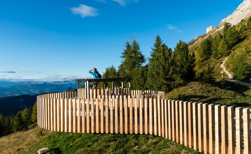
This varied circular hike combines the most beautiful natural and scenic highlights around the village of Karersee | Carezza and the imposing Latemar massif. The route begins behind the historic Grand Hotel, offering magnificent views of the rugged Latemar range. A suspension bridge crosses a small gorge and leads to the turquoise Lake Carezza (Karer See | Lago di Carezza). This emerald-green natural monument is not only known for its vivid colors, but also for the legend of the water nymph, which gives the lake a mysterious aura. The trail continues along pleasant paths to the Latemar rock labyrinth - a fascinating area of bizarre rock formations, hidden passages, and ancient steps carved into stone (in some sections the use of hands is required). Once on the Latemar meadows, a breathtaking panorama of the Rosengarten | Catinaccio opens up. Here, the Latmor Alm hut and the so-called “mountain sinema” invite hikers to pause and marvel. The return route takes you gently back over the Karerpass | Passo di Costalunga to the starting point - a hike full of variety and unforgettable views.
- Round trip
- Family-friendly
Refreshment stops:
- Golf. Food & Drinks at the Paolina parking lot - Opening hours and closing day: https://eggental.com/en/info/golf-food-drinks_10392
- Sea Bistro at Lake Carezza - Opening hours and closing day: https://eggental.com/en/info/sea-bistro_5234
- Latmor Alm hut on the Latemar meadows - Opening hours and closing day: https://eggental.com/en/info/malga-latmor-alm_24325
- Antermont restaurant at the Karerpass | Passo di Costalunga - Opening hours and closing day: https://eggental.com/en/info/bar-restaurant-pizzeria-antermont_5236
- Castel Latemar below the Karerpass | Passo di Costalunga - Opening hours and closing day: https://eggental.com/en/info/hotel-castel-latemar_5254
- Restaurant Pizzeria Hennenstall above the Paolina car park - Opening hours and closing day: https://eggental.com/en/info/hennenstall_5272
The route starts at the Paolina car park. First, follow path [6] towards Lake Carezza. A suspension bridge built in 2018 takes you across a small gorge to the parking area of Lake Carezza. Cross the lot and pass through an underpass to reach the lake itself. Follow the path along the right-hand shore until you reach the hiking path [11], which climbs steadily uphill to the Mitterleger | Radura di Mezzo viewpoint (1839 m). From here, turn onto the Labyrinth path [20], which winds its way through the striking rock formations of the Latemar labyrinth. At the junction with path [18], turn right in the direction of the Latemar saddle. After a steep ascent, you'll reach path [18A], which gently traverses a scenic alpine meadow. A short final climb brings you to the Latemar meadows and the Eggental mountain cinema (1861 m), offering stunning panoramic views of the Rosengarten | Catinaccio and the Rotwand | Roda di Vael. Right after the mountain cinema, the Latmor Alm hut is a perfect spot to rest and refuel with regional specialties while enjoying the magnificent Dolomite backdrop. To descend, follow path [17] down to the Karerpass | Passo di Costalunga. From there, path [6] on the left leads you back to the starting point at the Paolina car park.
Refreshment stops:
- Golf. Food & Drinks at the Paolina parking lot - Opening hours and closing day: https://eggental.com/en/info/golf-food-drinks_10392
- Sea Bistro at Lake Carezza - Opening hours and closing day: https://eggental.com/en/info/sea-bistro_5234
- Latmor Alm hut on the Latemar meadows - Opening hours and closing day: https://eggental.com/en/info/malga-latmor-alm_24325
- Antermont restaurant at the Karerpass | Passo di Costalunga - Opening hours and closing day: https://eggental.com/en/info/bar-restaurant-pizzeria-antermont_5236
- Castel Latemar below the Karerpass | Passo di Costalunga - Opening hours and closing day: https://eggental.com/en/info/hotel-castel-latemar_5254
- Restaurant Pizzeria Hennenstall above the Paolina car park - Opening hours and closing day: https://eggental.com/en/info/hennenstall_5272
Getting to the starting point of the tour by public transport is easy and convenient.
By public bus line:
- 180 from Bozen | Bolzano, Birchabruck | Ponte Nova, Welschnofen | Nova Levante, Karer See, Lago di Carezza
- 180 from Fassatal | Val di Fassa, Karer Pass | Passo Costalunga
- 184 from Weissenstein | Pietralba, Petersberg | Monte San Pietro, Deutschnofen | Nova Ponente, Stenk with change 180 (or 181 and change 180)
- 184 from Obereggen, Eggen | Ega with change 180 (or 184 and change 180)
- 186 from St. Zyprian | S. Cipriano, Nigerpass | Passo Nigra
- 187 from Steinegg | Collepietra, Gummer | San Valentino with change 180 (or 182 and change 180)
Bus stop: Paolina. Online timetable search at www.suedtirolmobil.info/en/
By car:
Destination: Karersee | Carezza
Parking: Parking lot Paolina
Parking: Parking lot Paolina, https://maps.app.goo.gl/3YHh2Jc8bFskkTXdA


