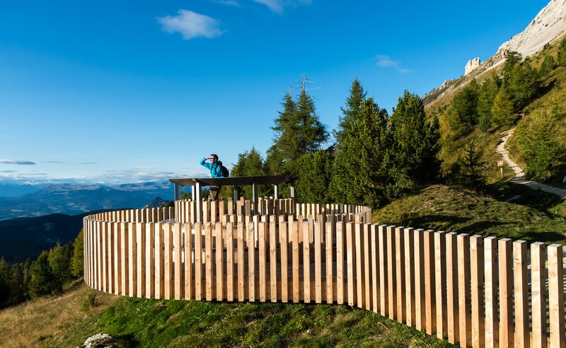
This circular hike from Steinegg|Collepietra combines nature, movement and breathtaking views. The first highlight is the Spitzköfele – a quiet lookout point offering a clear view of Steinegg|Collepietra, the Schlern|Sciliar and the Ritten|Renon high plateau. From there, the trail leads you to the heart of the tour: the Eggental Mountain Cinema – “Furner Oach”. Comfortable wooden chairs and a stylised cinema frame invite you to pause and take in the stunning panorama of the Rosengarten|Catinaccio, the Schlern|Sciliar, and – in the distance – the Zillertal Alps.
Toward the end of the route, the view opens up to a rare natural wonder: the earth pyramids of Steinegg|Collepietra, mysterious and fascinating. A hike that inspires wonder – step by step.
Important note: There are no refreshment stops along the entire circular route. However, at the start and end point in Steinegg|Collepietra, you will find several restaurants, cafés, and two shops.
- Geological highlights
- Insider tip
- Round trip
- Flora
The trekking tour starts at the village square in Steinegg|Collepietra, next to the Lex Market shop, following trail markers [2 | 7 | 8]. You first pass through a residential area, then continue along forest and meadow paths. Follow trail [8] to the junction with [8A], which leads you to the Spitzköfele, an idyllic viewpoint with a bench and table – perfect for a short break.
Above the Spitzköfele, the path climbs briefly before turning left onto trail [6], which takes you to the Steinegg Ridgeway [yellow shoe symbol]. Turn left and continue. After about 20 minutes, the route merges with a paved road that continues along the Ridgeway until you reach the sportszone Steinegg|Collepietra. Here, turn left onto trail [3]. Pass the Innerplatzer Farm and continue downhill until you meet trail [3A].
Follow this trail until you reach a clearing with a view of the main road Steinegg|Collepietra – Gummer|San Valentino in Campo. At the water reservoir, leave the trail markers and turn left along the road towards the double bend, where you’ll already spot the mountain cinema “Furner Oach”.
After an extended panoramic break, follow the short stretch of road back to the trail and continue downhill along trail [3A]. After around 20 minutes, cross a road, descend a staircase, and follow the steep path past meadows and farms. On the right, you’ll spot the earth pyramids of Steinegg|Collepietra.
At the end of trail [3A], turn left onto trail [2] and follow the markings through the Katzenbach Gorge until you reach the village entrance and the chapel “Zum Weißen Bild”. From there, it’s only 10 minutes back to the starting point at the village square.
Getting to the starting point of the tour by public transport is easy and convenient.
By public bus line
- 182 from Bozen | Bolzano
- 187 from Welschnofen | Nova Levante
- 180 from Karersee | Lago di Carezza, Karerpass | Passo Costalunga, Val di Fassa*
- 184 from Oberggen, Eggen | Ega*
- 181 from Weissenstein | Pietralba, Petersberg | Monte San Pietro, Deutschnofen | Nova Ponente, Stenk*
- 187 or 182 from Gummer | San Valentino in Campo
*change in Birchabruck | Ponte Nova to the line 182
Bus stop: Steinegg | Collepietra Village;
online timetable search at South Tyrol Mobility
Starting point: Steinegg | Collepietra Village
By car:
Destination: Steinegg | Collepietra
Parking: next to the main road in front of the Cafè Christl - Parking Village Square Steinegg
Starting point: Steinegg | Collepietra Village
Starting point: Steinegg | Collepietra Village
Hiking boots
sufficient water
snack (there are no opportunities to stop for refreshments directly on the trail)


