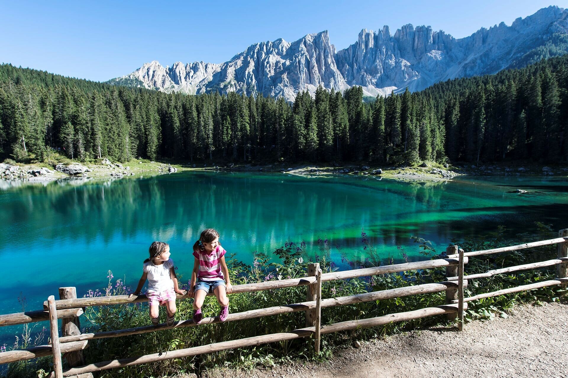
Top

Parcours moyen autour du lac de Karer

Welschnofen
Add to favourites
Difficulty
Easy
Activity time
0:45
Duration in hours
Distance
2.7
Distance in km
Suggested period
Jan
Feb
Mar
Apr
May
Jun
Jul
Aug
Sep
Oct
Nov
Dec
Medium circular route at Lake Karer, the colorful Rainbow Lake, with suspension bridge, forest path, and view of the Dolomites – a protected natural monument to marvel at and enjoy.

Lake Karer in the Eggental is famous for its extraordinary colors and is therefore also called “Lec de Ergobando” – Rainbow Lake. With a length of about 300 meters and a width of approximately 140 meters, it is one of South Tyrol's best-known natural jewels. It is fed by underground springs from the Latemar range, which is why its size and depth can vary greatly depending on the season and weather.

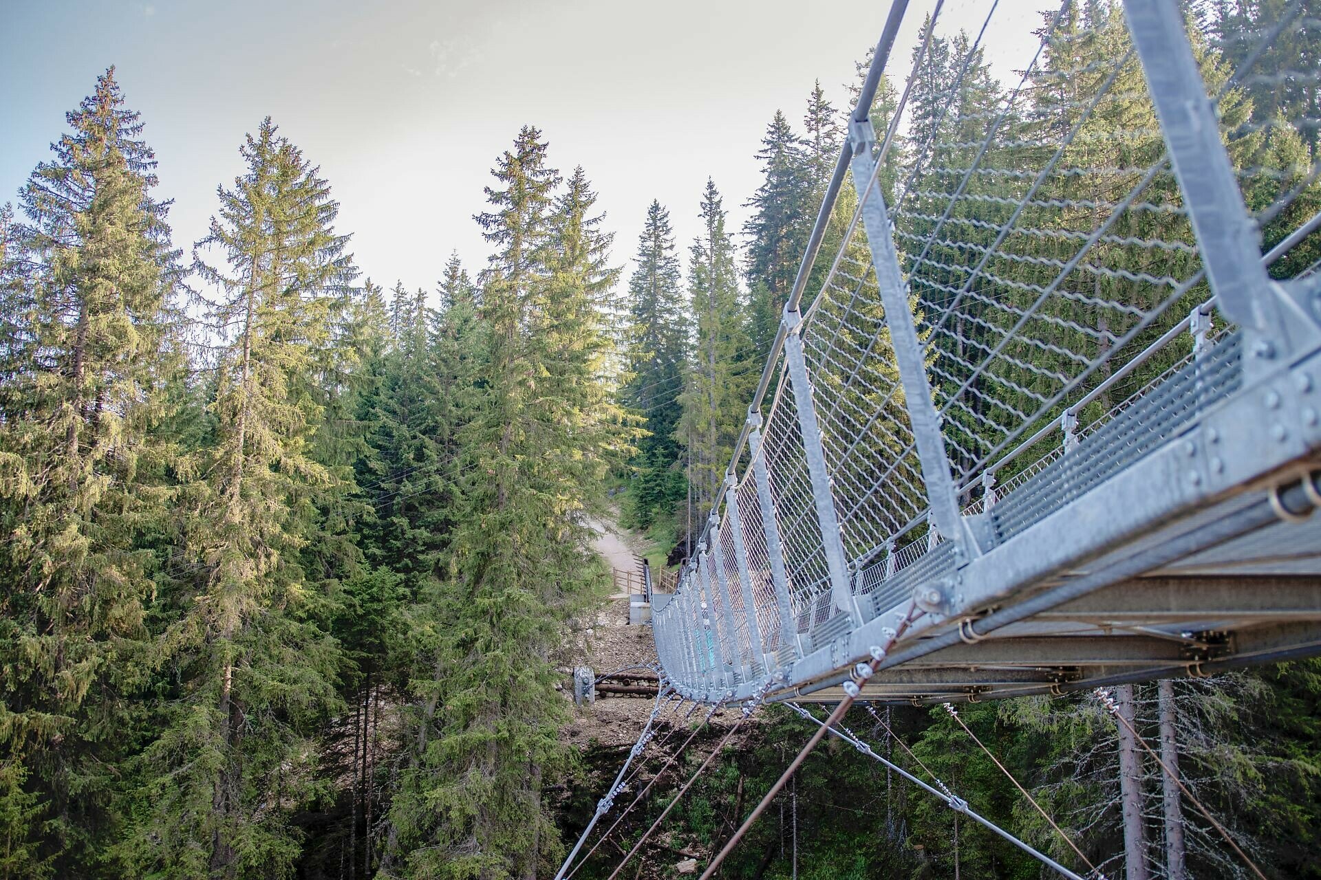
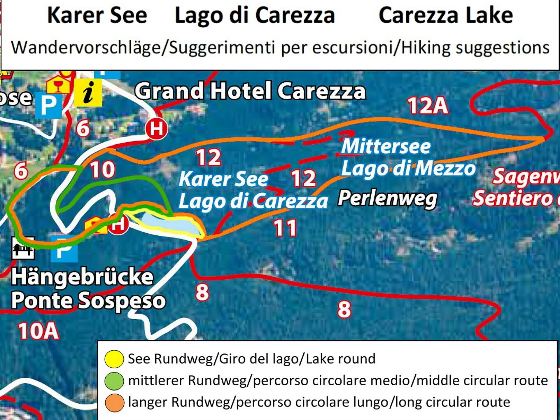
The medium circular route starts at Lake Karer, crosses the suspension bridge towards the holiday settlement, and then leads back through idyllic forest areas to the starting point at the lake. Besides Lake Karer itself, the suspension bridge, built in 2018 as a connection to the Karerseesiedlung, is another special highlight for visitors.

As a protected natural monument, Lake Karer deserves special respect. It is important to observe the designated protection boundaries so that the beauty of this unique mountain lake can be preserved for the future.

Route info
Easy
Distance
2,7 km
Activity time
45 min
Ascent
69 m
Descent
69 m
Physical effort
Scenary
Highest point
1.603 m
Lowest point
1.540 m
Suggestions
Dining option at the visitor center: Sea Bistro - opening hours and day off: https://eggental.com/de/infos/sea-bistro_5234
Safety guidelines
As a protected natural monument, Lake Karer deserves special respect. It is important to observe the designated protection boundaries so that the beauty of this unique mountain lake can be preserved for the future.
Directions
Medium circular hike around Lake Karer | green marking
The starting point is at the Lake Karer parking lot. At the end of the parking lot, you cross the suspension bridge and then follow path [6] steeply upwards towards the Karer Pass. At the Hotel Restaurant Lake & River, you cross the street, turn right, and on path [10], you go back to Lake Karer. If desired, you can also walk around the lake at Lake Karer and then return to the starting point.

Dining option at the visitor center: Sea Bistro - opening hours and day off: https://eggental.com/de/infos/sea-bistro_5234
public transportation

The starting point of the route is easily reachable by public transport.

By public bus line:
- 180 from Bolzano, Birchabruck, Nova Levante
- 180 from Fassa Valley, Karer Pass, Lake Karer
- 184 from Weissenstein, Petersberg, Deutschnofen, Stenk with transfer to 180 (or: 181 and transfer to 180)
- 184 from Obereggen, Eggen with transfer to 180 (or: 184 and transfer to 180)
- 186 from St. Zyprian, Niger Pass with transfer to 180
- 187 from Steinegg, Gummer with transfer to 180 (or: 182 and transfer to 180)

Stop: Lake Karer. Online timetable search at South Tyrol Mobility: www.suedtirolmobil.info

How to get there

The starting point of the route is easily reachable by public transport.

By public bus line:
- 180 from Bolzano, Birchabruck, Nova Levante
- 180 from Fassa Valley, Karer Pass, Lake Karer
- 184 from Weissenstein, Petersberg, Deutschnofen, Stenk with transfer to 180 (or: 181 and transfer to 180)
- 184 from Obereggen, Eggen with transfer to 180 (or: 184 and transfer to 180)
- 186 from St. Zyprian, Niger Pass with transfer to 180
- 187 from Steinegg, Gummer with transfer to 180 (or: 182 and transfer to 180)

Stop: Lake Karer. Online timetable search at South Tyrol Mobility: www.suedtirolmobil.info

By car: 
Destination: Lake Karer
Parking: Lake Karer parking lot

Where to park
Parking: Lake Karer parking lot (paid), https://goo.gl/maps/w4SVXQJJyxtUaLdUA
You might be interested in
Discover related tours
Obereggen, Deutschnofen
LATEMAR.PANORAMA
Distance 7,8 km
Activity time 2 h 45 min
Ascent 415 m
Descent 417 m
Welschnofen
Sissi Tour
Distance 10,3 km
Activity time 2 h 53 min
Ascent 357 m
Descent 357 m
Obereggen, Deutschnofen
Family-hike from the Lavazè Mountain Pass to the Lieg Alm Hut
Distance 5,1 km
Activity time 1 h 20 min
Ascent 78 m
Descent 78 m
Intermediate
Add to favourites
Welschnofen
Du lac de Karer au labyrinthe rocheux du Latemar
Distance 9,4 km
Activity time 2 h 55 min
Ascent 457 m
Descent 457 m
Welschnofen
Circular lake hike to Lake Carezza and Lake Mittersee
Distance 5,7 km
Activity time 1 h 35 min
Ascent 127 m
Descent 122 m
Intermediate
Add to favourites
Welschnofen
Randonnée entre fermes à Welschnofen
Distance 10,6 km
Activity time 3 h 14 min
Ascent 477 m
Descent 477 m