Top

Planet Trail in Gummer

Steinegg
Add to favourites
Difficulty
Easy
Activity time
3:00
Duration in hours
Distance
9.2
Distance in km
Suggested period
Jan
Feb
Mar
Apr
May
Jun
Jul
Aug
Sep
Oct
Nov
Dec
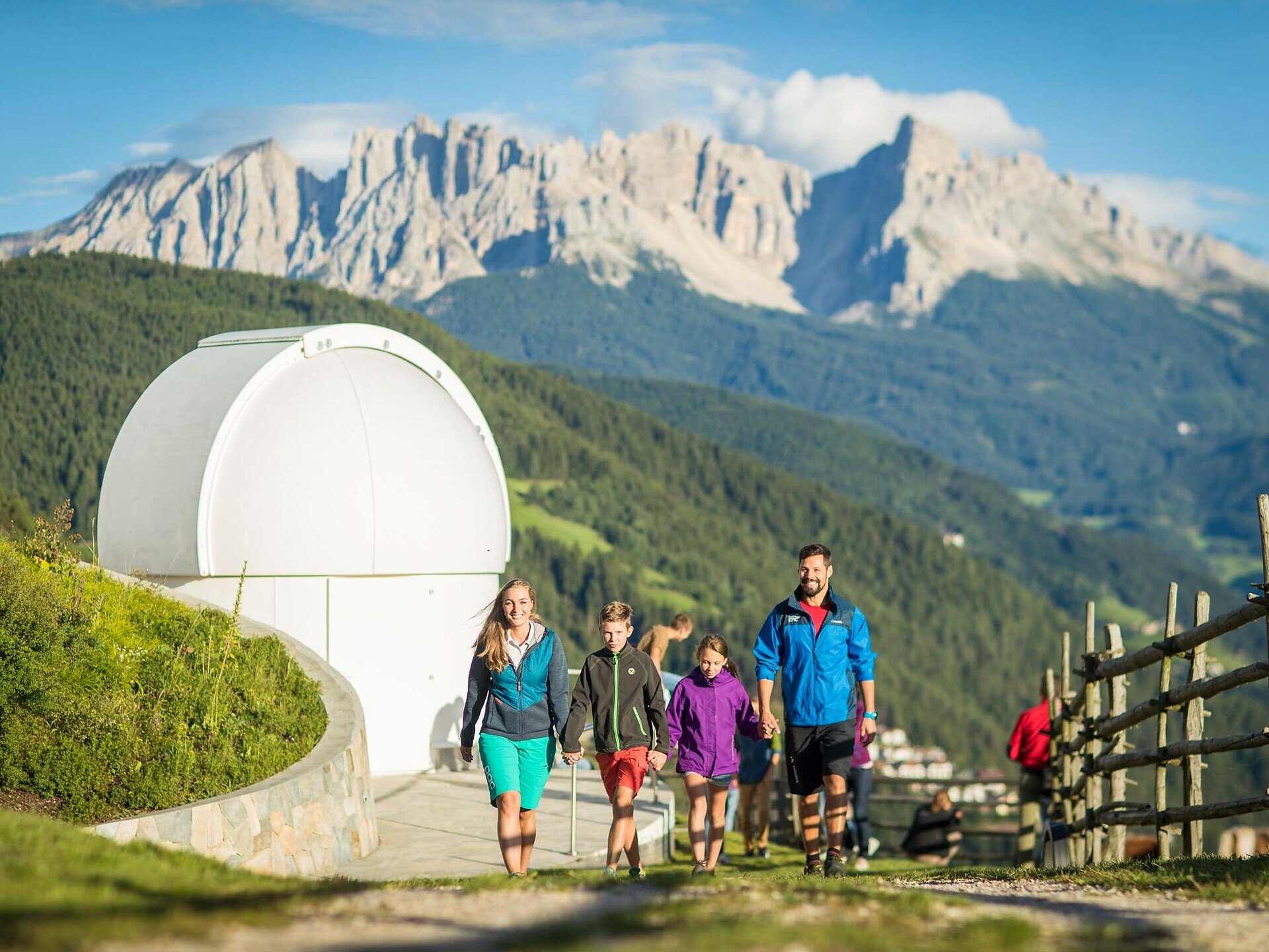
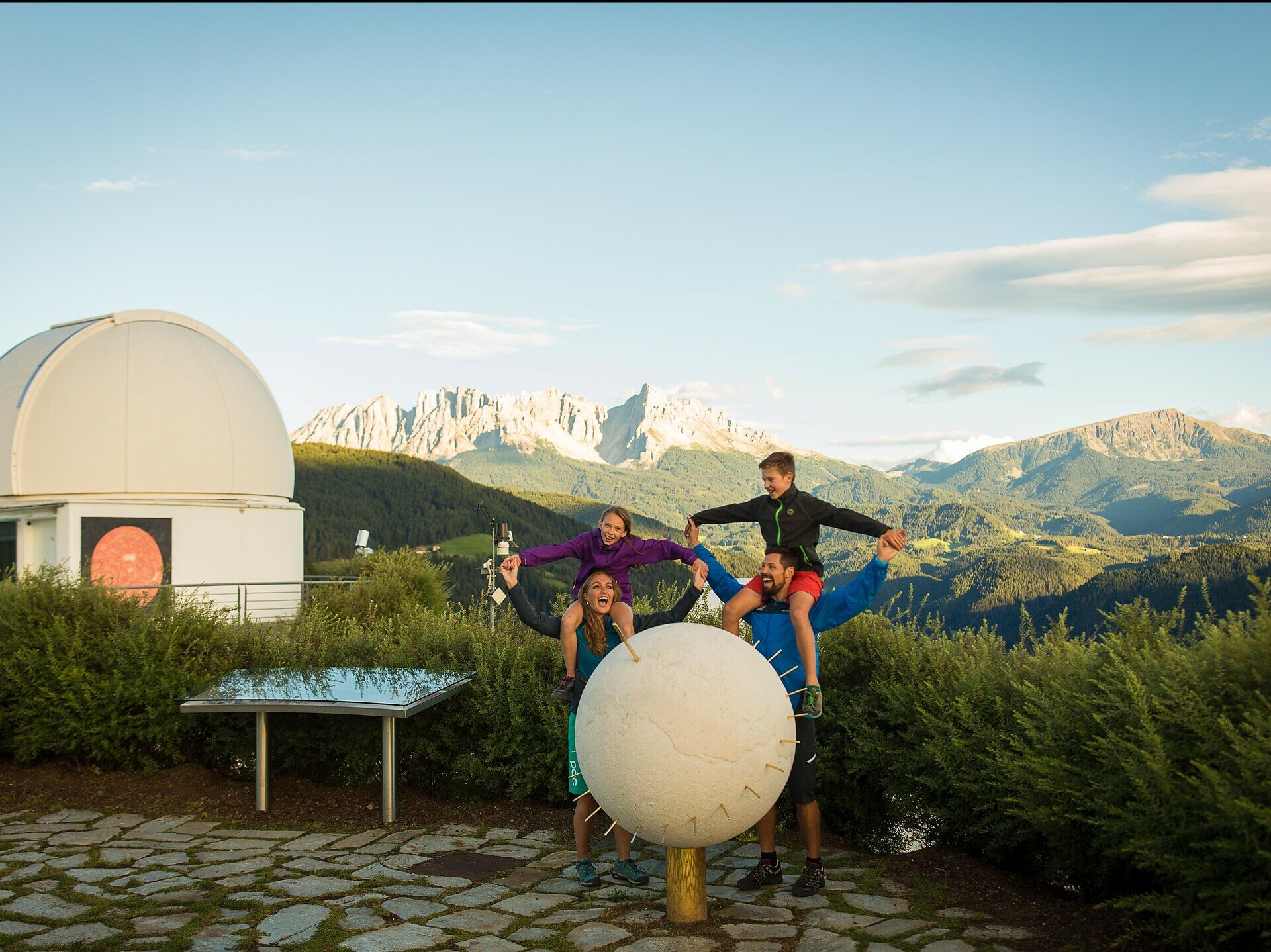
The Planet Trail takes you on an exciting hike through our solar system at a scale of 1:1 billion. At nine stations, you will learn fascinating facts about our planets.
You hike through the beautiful natural landscape of the Eggental and embark on a journey through our solar system – the Planet Trail makes it possible! This special hike brings you closer to the fascinating vastness of the universe. 

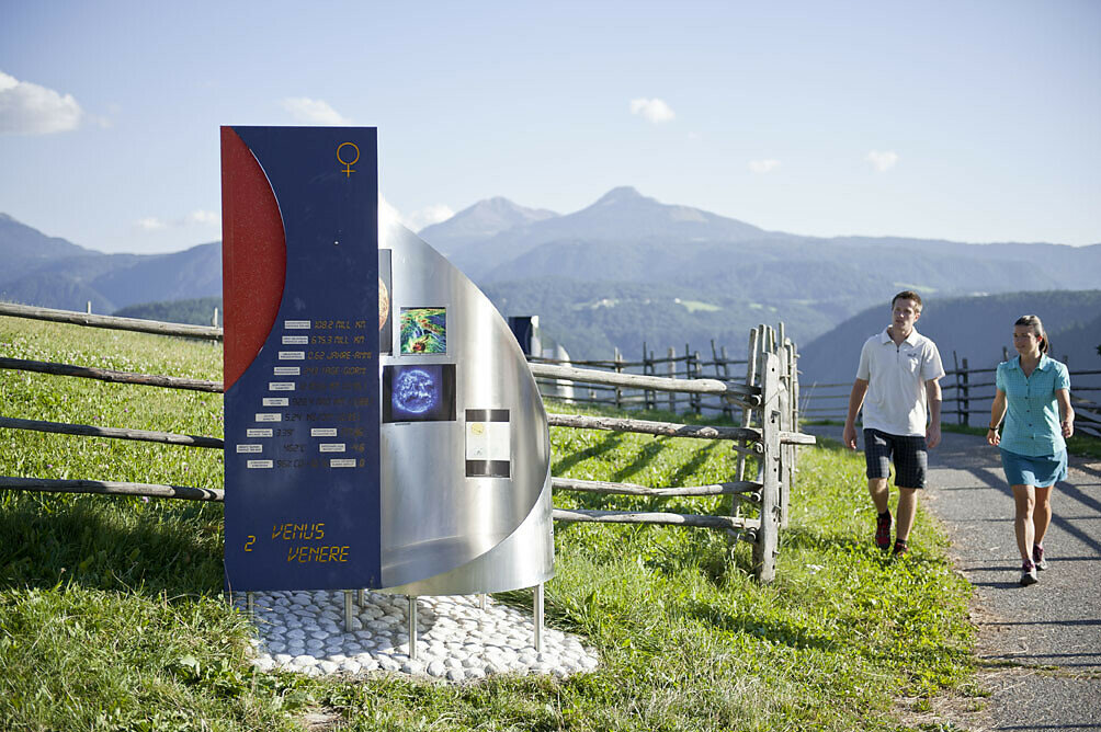
Starting from our star, the sun, which is visible on the wall of the observatory, you encounter all 8 planets of our solar system as well as the dwarf planet Pluto, all at their scaled distances from the sun. Each step you take corresponds to about 1 million kilometers. And yet, it will take you nearly 3 hours to visit all the planets. 
At each station, you learn exciting facts about the celestial bodies and their unique characteristics. 
TIP Audio guide:
Download the free izi.TRAVEL app on your phone and search for the "Planet Trail in Gummer". Activate the GPS function on your phone and you will have your very own audio guide with you on the route. At each planet station, this digital guide tells you interesting facts about the respective planet.

The Planet Trail is not only an adventure for all who are interested in astronomy but also for nature lovers who want to enjoy the peace and beauty of the South Tyrolean landscape.
The route is easy to walk and leads you through idyllic forests, over gentle hills, and along viewpoints that repeatedly offer you new views of the mountain world. 

Please note: There are no catering facilities along the entire circular hike.
At the start or end point of this hike, however, there is the Gasthaus Unteregger, which spoils you with South Tyrolean specialties.
Route info
Easy
Distance
9,2 km
Activity time
3 h 00 min
Ascent
262 m
Descent
262 m
Physical effort
Scenary
Highest point
1.425 m
Lowest point
1.288 m
Suggestions
Download the free izi.TRAVEL app on your phone and search for the "Planet Trail in Gummer". Activate the GPS function on your phone and you will have your very own audio guide with you on the route. At each planet station, this digital guide tells you interesting facts about the respective planet.
Directions

Starting from the Max Valier Observatory, you immediately reach the 1st planet Mercury, then the 2nd planet Venus and at Untereggerhof the Earth. The Planet Trail then continues along the hiking path, gently ascending towards the north, past a small private pond, to Oberegger where you reach the 4th planet Mars. From there, the Planet Trail leads around the Oberegger farm, along the trail marker [5] eastward, where the path ascends to the 5th planet Jupiter. Always following marker [5], slightly ascending through the forest to the Malgeier farmstead, you meet the 6th planet Saturn with a great view of the Dolomite massif Latemar. From Saturn, the Planet Trail continues along the paved access road towards the north. From here it follows marker [5] downhill through the forest to a biotope. The flat path continues east to the end of the biotope. Here the path turns north, initially along a well-trodden forest path and then along an ascending forest path to the state road. Cross this and follow hiking trail [1/3] to the country inn Lärchenwald, where the 7th planet Uranus is located. From here, follow hiking trail [1] past Jaiterhof, further towards Haus Waldpeter, and just above Haus Waldpeter you reach the highest point (1,420m) of the circular Planet Trail. From here, follow the special Planet Trail signs to the 8th planet Neptune. Then, the Planet Trail leads down forest paths to the Schenk parking lot at the Lantschnay bus stop. The path then runs [5A] along the paved road past the Learn pond. Shortly after Hinteregger farm, the path turns right at the forest edge towards Edenhof. Follow the planet signs and you pass Tschigg farm, where the 9th planet or dwarf planet Pluto is located. Following the planet signs, you return to the starting point.

public transportation
The starting point of the route is easy and convenient to reach by public transport.

By public bus line:
- 182 from Bolzano and Steinegg
- 180 from Welschnofen, Karersee, Karerpass, Fassatal*
- 184 from Obereggen, Eggen*
- 181 from Weissenstein, Petersberg, Deutschnofen, Stenk*
- 182 from Gummer
*Change in Birchabruck to line 182

Stop: Lantschnay
Online timetable search at Südtirol mobil
Walk of 2.5 km (approx. 40 minutes) from the Schenk parking lot to the observatory where the Planet Trail starts. This walk to the starting point is also the final section of the Planet Trail.
How to get there

The starting point of the route is easy and convenient to reach by public transport.

By public bus line:
- 182 from Bolzano and Steinegg
- 180 from Welschnofen, Karersee, Karerpass, Fassatal*
- 184 from Obereggen, Eggen*
- 181 from Weissenstein, Petersberg, Deutschnofen, Stenk*
- 182 from Gummer
*Change in Birchabruck to line 182

Stop: Lantschnay
Online timetable search at Südtirol mobil
Walk of 2.5 km (approx. 40 minutes) from the bus stop to the observatory where the Planet Trail starts. This walk to the starting point is also the final section of the Planet Trail.

By car:
Destination: Max Valier Observatory - Obergummer
Parking: Parking at the Gasthof Unteregger or at the observatory. This is also where the Planet Trail begins.

Where to park

Parking at the Gasthof Unteregger or at the observatory. This is also where the Planet Trail begins.

Sturdy footwear, sun protection, and enough water
You might be interested in
Discover related tours
Intermediate
Add to favourites
Welschnofen, Steinegg
Circular hike at Taltbühl to Totmoos and Wolfsgrube
Distance 10,3 km
Activity time 3 h 03 min
Ascent 391 m
Descent 387 m
Karersee, Welschnofen
Circular hike in Karersee | Carezza between Rosengarten | Catinaccio and Latemar
Distance 14,8 km
Activity time 4 h 15 min
Ascent 440 m
Descent 439 m
Obereggen, Deutschnofen
LATEMAR.PANORAMA: Family-hike on the nature-trail
Distance 10,6 km
Activity time 3 h 50 min
Ascent 471 m
Descent 991 m
Welschnofen
Stadlalm Tour
Distance 7,7 km
Activity time 2 h 00 min
Ascent 203 m
Descent 203 m
Karersee, Welschnofen
Family hike from the Nigerpass | Passo Nigra to the Messnerjoch hut
Distance 3,9 km
Activity time 1 h 16 min
Ascent 242 m
Descent 242 m
Intermediate
Add to favourites
Steinegg
Mountain Cinema in the Eggental - Furner Oach
Distance 10,7 km
Activity time 3 h 30 min
Ascent 540 m
Descent 540 m
© Carezza Dolomites/Harald Wisthaler
Information & prices
Ski passes
Winter 2024/25

Here you will find all important information on skipasses, daily, multi-day, and seasonal tickets at a glance. All ski passes can be purchased quickly and conveniently online. Buy your skipass directly from home and get a 5% discount!

To the ski passes & tickets