Top

Hike to the Wölflhof

Deutschnofen
Add to favourites
Difficulty
Intermediate
Activity time
2:30
Duration in hours
Distance
9
Distance in km
WSEN
Suggested period
Jan
Feb
Mar
Apr
May
Jun
Jul
Aug
Sep
Oct
Nov
Dec
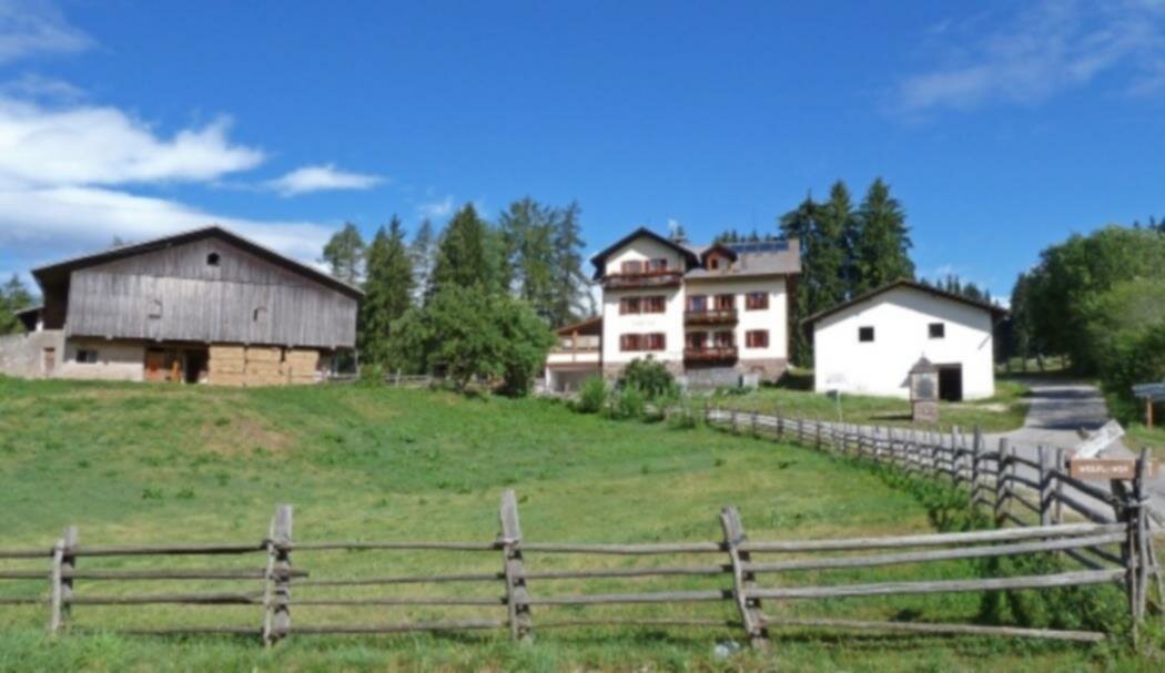
Scenic hike to Wölflhof with local food and Dolomite views – ideal for nature lovers, hikers, and those who enjoy a rewarding rest stop.

This hike is a perfect blend of nature, relaxation, and local flavor. Starting from the edge of Deutschnofen, the route leads through peaceful roads, open meadows, and quiet forest trails – with views that become more impressive with every step.

The destination is the Wölflhof, a welcoming, family-run farmhouse where hikers can enjoy hearty South Tyrolean dishes and genuine hospitality. It’s the ideal spot to take a break and soak in the surrounding peace.

The return leg offers wide, sweeping views of the Sarntal valley, the Ritten plateau, the Schlern, and – on clear days – even the South Tyrolean lowlands and the Brenta Dolomites. A hike made for nature lovers, foodies, and anyone who enjoys quiet paths with great rewards.

Route info
Intermediate
Distance
9,0 km
Activity time
2 h 30 min
Ascent
210 m
Descent
210 m
Physical effort
Scenary
Highest point
1.429 m
Lowest point
1.284 m
Directions

The hike starts at Café Bar Luise in Deutschnofe. Follow the paved road past the sports center.

Then take trail [5], which turns into a pleasant country path, and continue along trail [5A] to reach the Unterkaplunhof at 1,301 m.

From there, follow forest trail [3], which climbs gently to the Wölflhof at 1,290 m. The farm offers local food and is perfect for a relaxing break.

The return route follows the European long-distance trail [E5], passing by the Gattererhof, where you'll enjoy sweeping views of the Sarntal valley, Ritten plateau, Schlern, and – on clear days – the South Tyrolean lowlands, Salurner Klause, and the Brenta Dolomites.

Head back on gravel and paved roads to the village center of Deutschnofen, completing the scenic loop.

public transportation
Getting to the starting point of the tour by public transport is easy and convenient.

By public bus line:
- 181 from Bozen | Bolzano, Birchabruck | Ponte Nova
- 180 and change 181 from Karersee | Carezza, Karerpass | Passo Costalunga, Welschnofen | Nova Levante
- 181 from Weissenstein | Pietralba, Petersberg | Monte San Pietro
- 184 from Obereggen, Eggen | Ega
- 182 and change 181 from Steinegg | Collepietra, Gummer | San Valentino

Bus stop: Nova Ponente/Deutschnofen Bar Luise; online bus timetables: www.suedtirolmobil.info/en/
How to get there

Getting to the starting point of the tour by public transport is easy and convenient.

By public bus line:
- 181 from Bozen | Bolzano, Birchabruck | Ponte Nova
- 180 and change 181 from Karersee | Carezza, Karerpass | Passo Costalunga, Welschnofen | Nova Levante
- 181 from Weissenstein | Pietralba, Petersberg | Monte San Pietro
- 184 from Obereggen, Eggen | Ega
- 182 and change 181 from Steinegg | Collepietra, Gummer | San Valentino

Bus stop: Nova Ponente/Deutschnofen Bar Luise; online bus timetables: www.suedtirolmobil.info/en/

By car:
Destination: Deutschnofen | Nova Ponente
Parking: Parking lot Bar Luise
Meeting Point: Bar Luise: https://goo.gl/maps/KchtTwNgUikL7h73A

Where to park

Parking: Parking lot Bar Luise
Meeting Point: Bar Luise: https://goo.gl/maps/KchtTwNgUikL7h73A

You might be interested in
Discover related tours
Deutschnofen
Hike from Passo Oclini at the top of the Corno Bianco
Distance 1,5 km
Activity time 1 h 00 min
Ascent 306 m
Descent 13 m
Intermediate
Add to favourites
Welschnofen
Hike: Nova Levante to the Stadl Alm farm and Karersee Lake
Distance 13,6 km
Activity time 3 h 59 min
Ascent 481 m
Descent 468 m
Intermediate
Add to favourites
Karersee, Welschnofen
Hike from San Cipriano/Passo Nigra/Malga Frommer hut to Passo Costalunga
Distance 11,6 km
Activity time 3 h 55 min
Ascent 818 m
Descent 89 m
Welschnofen
Short village-walk Nova Levante
Distance 4,2 km
Activity time 1 h 12 min
Ascent 130 m
Descent 130 m
Intermediate
Add to favourites
Karersee, Welschnofen
From the Karerpass | Passo di Costalunga to the Latemar Labyrinth
Distance 8,7 km
Activity time 2 h 29 min
Ascent 220 m
Descent 220 m
Intermediate
Add to favourites
Welschnofen
Sissi Tour
Distance 9,8 km
Activity time 2 h 53 min
Ascent 357 m
Descent 357 m
© Carezza Dolomites/Harald Wisthaler
Information & prices
Ski passes
Winter 2024/25

Here you will find all important information on skipasses, daily, multi-day, and seasonal tickets at a glance. All ski passes can be purchased quickly and conveniently online. Buy your skipass directly from home and get a 5% discount!

To the ski passes & tickets