Top

Hike through the Bletterbachschlucht Gorge

Deutschnofen
Add to favourites
Difficulty
Intermediate
Activity time
4:00
Duration in hours
Distance
11.5
Distance in km
WSEN
Suggested period
Jan
Feb
Mar
Apr
May
Jun
Jul
Aug
Sep
Oct
Nov
Dec
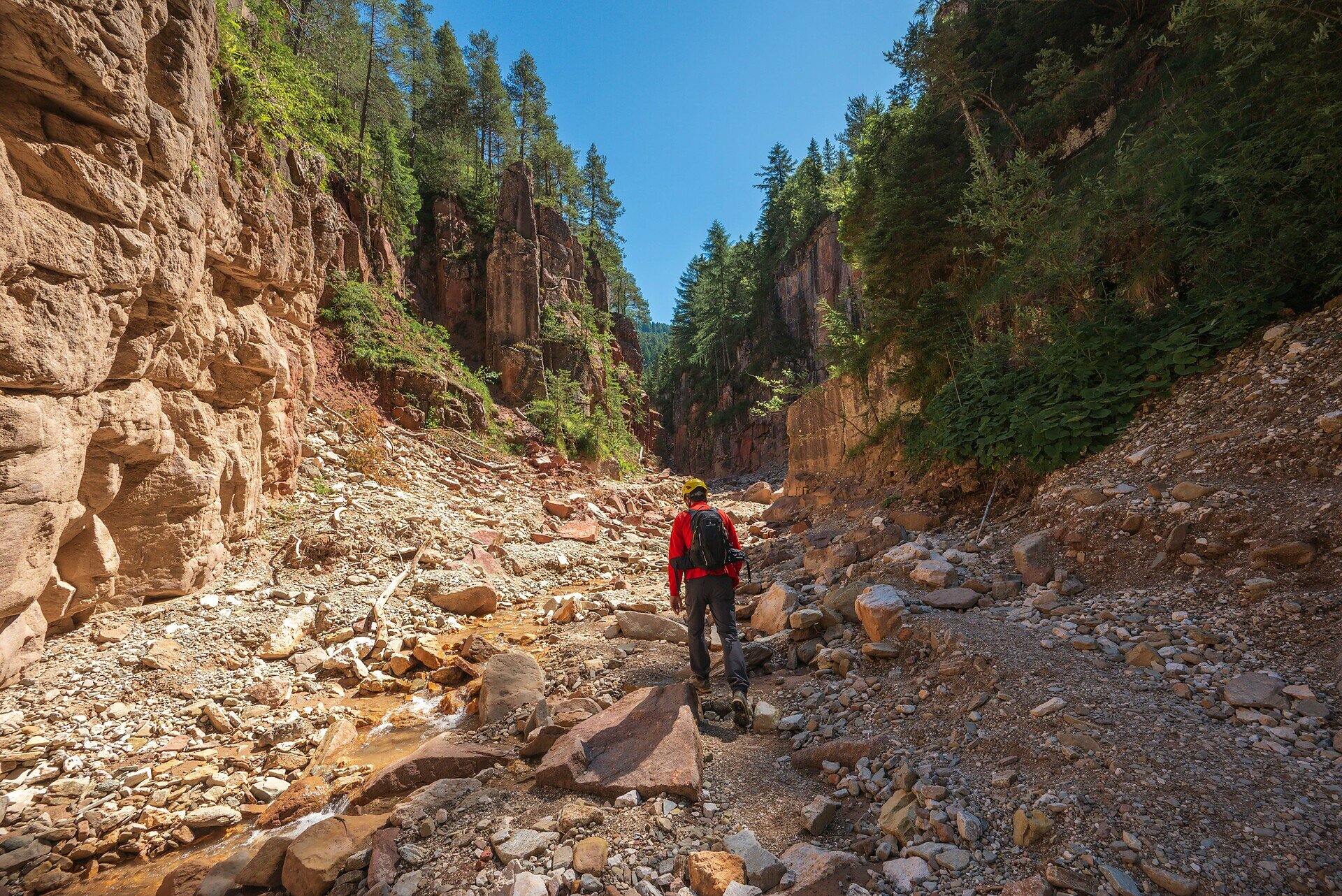
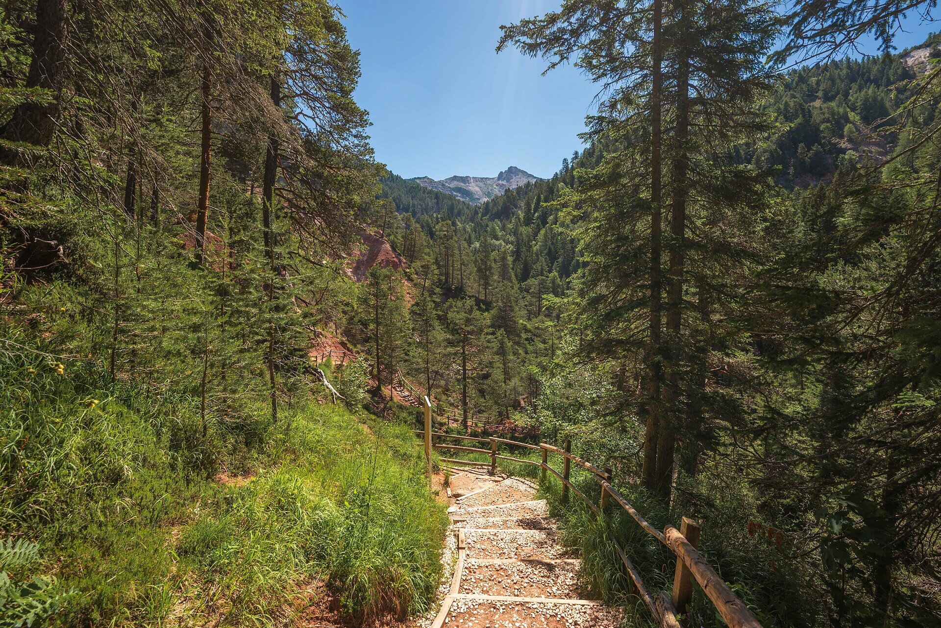
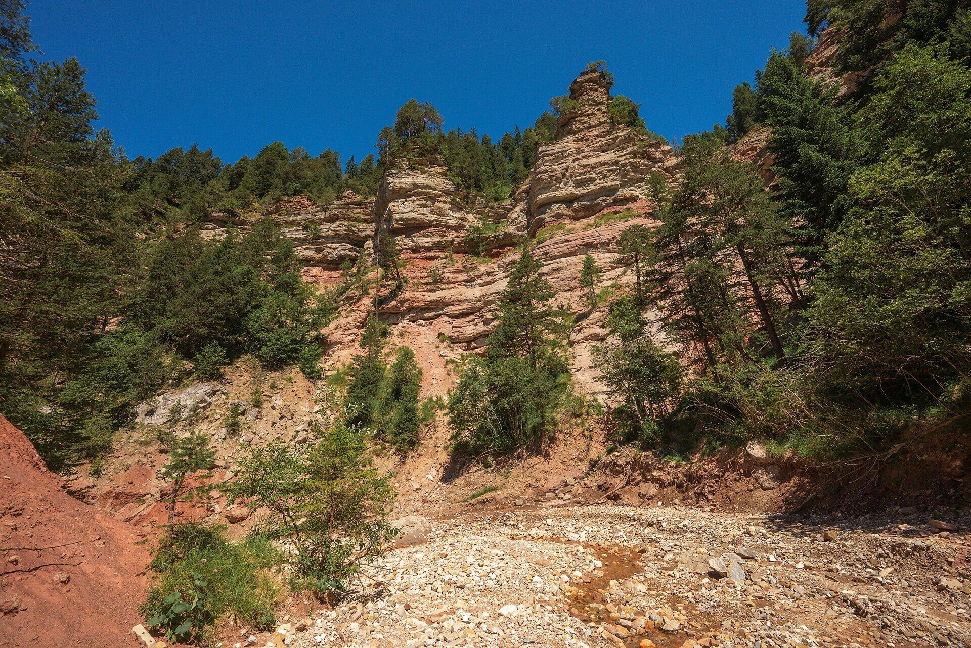
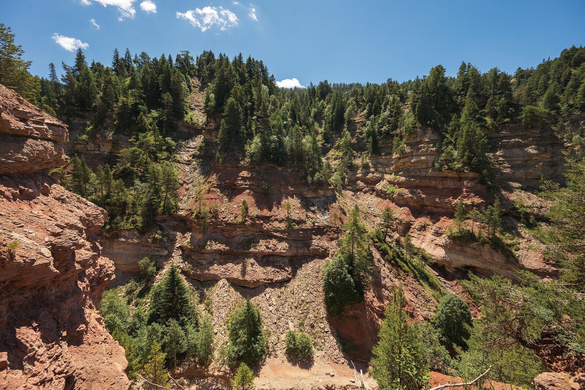
From Maria Weißenstein through pastures into Bletterbach Gorge – a must for hikers, nature lovers, and those seeking cultural insight.

This hike offers a powerful blend of breathtaking nature and spiritual reflection. Starting at the famous pilgrimage site of Maria Weißenstein, hikers can take a moment of stillness at the monastery and explore the moving votive tablets that tell stories of hope and faith. The trail continues through quiet forests and picturesque alpine meadows, leading into the awe-inspiring Bletterbach Gorge. Often referred to as South Tyrol’s “Grand Canyon,” the gorge reveals dramatic rock layers, unique formations, and an open window into Earth’s geological past. Perfect for hikers who seek more than just scenery – this experience connects nature, culture, and soul in an unforgettable journey.

Route info
Intermediate
Distance
11,5 km
Activity time
4 h 00 min
Ascent
600 m
Descent
600 m
Physical effort
Scenary
Highest point
1.694 m
Lowest point
1.416 m
Directions

The hike begins at the well-known pilgrimage site of Maria Weißenstein (1,520 m). Take a moment to visit the peaceful monastery before setting off. From the parking area, follow the well-marked trail [S] through light forests and alpine pastures to the Schmiederalm (1,737 m) – a great spot for a short break. Continue along trail [S] to the Lahneralm (1,583 m), where the first views of the dramatic Bletterbach Gorge appear.

From there, the trail descends into the Bletterbach Gorge, revealing fascinating rock layers and geological formations. A detour to the visitor center in Aldino is optional. After exploring the gorge, follow trail [3] through the peaceful Kösertal valley, offering beautiful views of the Weißhorn.

The return route takes you along trails [E5], [3], and finally [15], leading you back to your starting point at Maria Weißenstein. A scenic circular hike full of natural beauty and cultural highlights.

public transportation

Getting to the starting point of the tour by public transport is easy and convenient.

By public bus line:
- 180 or 181 from Bozen | Bolzano
- 180 or 184 from Karersee | Lago di Carezza, Karerpass | Passo Costalunga, Welschnofen | Nova Levante
- 184 from Birchabruck | Ponte Nova, Stenk, Eggen | Ega
- 184 from Petersberg | Monte San Pietro,  Deutschnofen | Nova Ponente
- 182 from Steinegg | Collepietra, Gummer | San Valentino
- 180 from Val di Fassa

Bus stop: Weissenstein | Pietralba; online timetable search at www.suedtirolmobil.info/en/ Meeting point: Weissenstein | Pietralba: https://goo.gl/maps/BNSP7XGxA78ptriZ7

How to get there

Getting to the starting point of the tour by public transport is easy and convenient.

By public bus line:
- 180 or 181 from Bozen | Bolzano
- 180 or 184 from Karersee | Lago di Carezza, Karerpass | Passo Costalunga, Welschnofen | Nova Levante
- 184 from Birchabruck | Ponte Nova, Stenk, Eggen | Ega
- 184 from Petersberg | Monte San Pietro,  Deutschnofen | Nova Ponente
- 182 from Steinegg | Collepietra, Gummer | San Valentino
- 180 from Val di Fassa

Bus stop: Weissenstein | Pietralba; online timetable search at www.suedtirolmobil.info/en/
Meeting point: Weissenstein | Pietralba: https://goo.gl/maps/BNSP7XGxA78ptriZ7

By car:
Destination: Weissenstein  | Pietralba
Parking: Parking lot Weissenstein  | Pietralba
Meeting point: Weissenstein | Pietralba: https://goo.gl/maps/BNSP7XGxA78ptriZ7

Where to park

Parking: Parking lot Weissenstein  | Pietralba
Meeting point: Weissenstein | Pietralba: https://goo.gl/maps/BNSP7XGxA78ptriZ7

You might be interested in
Discover related tours
Welschnofen
Family hike to the Messnerjoch hut
Distance 4,3 km
Activity time 1 h 22 min
Ascent 232 m
Descent 232 m
Welschnofen, Karersee
Hike from Lake Carezza to Passo Costalunga
Distance 3,2 km
Activity time 1 h 03 min
Ascent 201 m
Descent 0 m
Karersee, Deutschnofen, Welschnofen
Alpine Ridgeway from the Latemar mountain to the Rosengarten mountain
Distance 25,8 km
Activity time 6 h 30 min
Ascent 1.579 m
Descent 1.944 m
Status
open
Deutschnofen
Family-hike from Eggen/Ega to the "Egg" farms
Distance 4,0 km
Activity time 1 h 15 min
Ascent 208 m
Descent 208 m
Intermediate
Add to favourites
Karersee, Welschnofen
To the Christomannos monument
Distance 9,7 km
Activity time 3 h 11 min
Ascent 616 m
Descent 616 m
Obereggen, Deutschnofen
LATEMAR.PANORAMA: Family-hike on the nature-trail
Distance 10,6 km
Activity time 3 h 14 min
Ascent 486 m
Descent 1.014 m
© Carezza Dolomites/Harald Wisthaler
Information & prices
Ski passes
Winter 2024/25

Here you will find all important information on skipasses, daily, multi-day, and seasonal tickets at a glance. All ski passes can be purchased quickly and conveniently online. Buy your skipass directly from home and get a 5% discount!

To the ski passes & tickets