


Dolomites World Heritage Geotrail II - 2nd Stage: From Lavazèjoch to Karer Pass

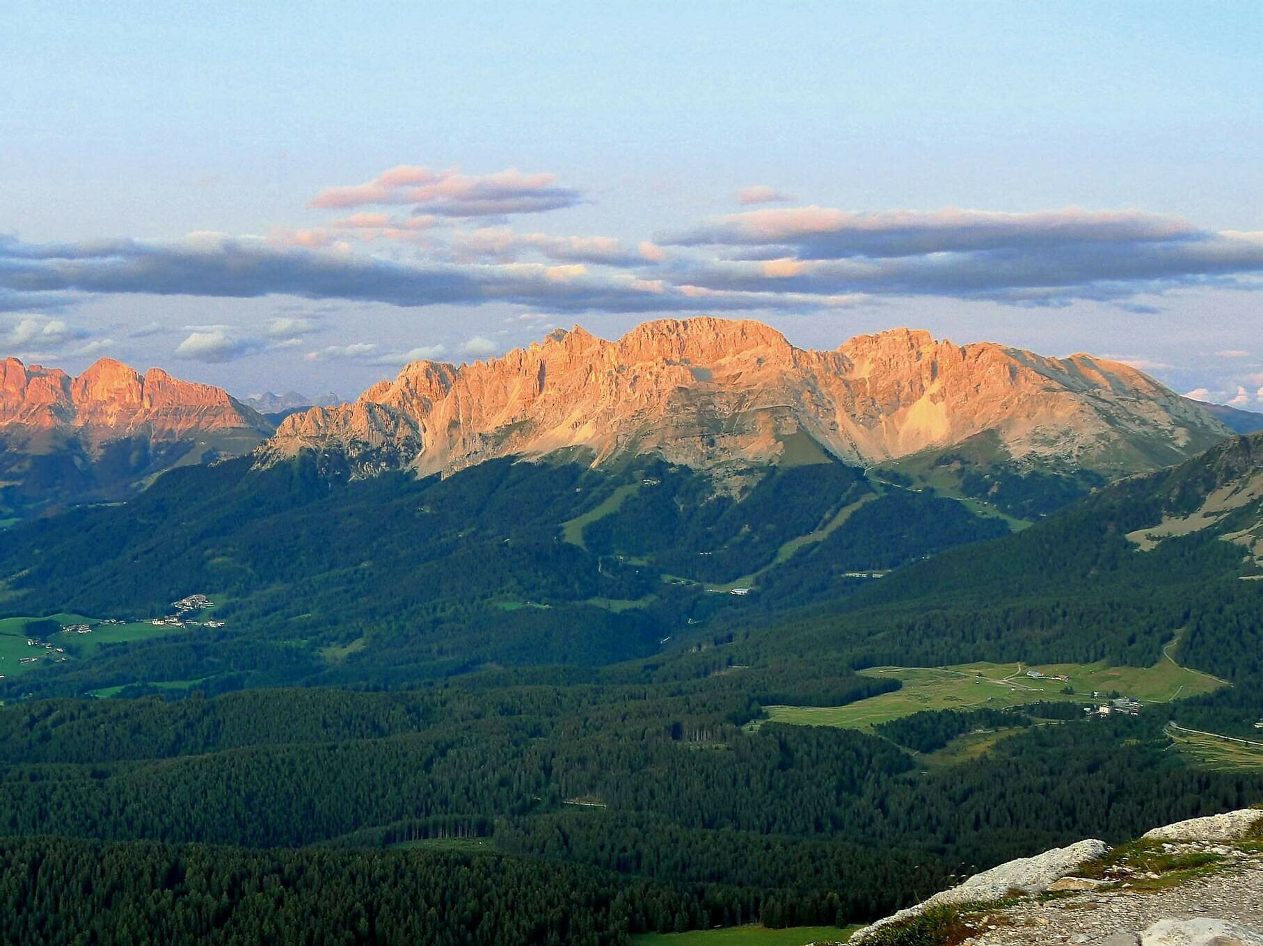
This stage of the Dolomites World Heritage Geotrail passes through one of the most impressive landscapes of the Dolomites – from the idyllic Lavazèjoch to the legendary Karer Pass. Below the majestic Latemar walls, the path runs through quiet forests, vast alpine meadows, and impressive scree basins that tell the geological history of this region. Spectacular views of the distinctive peaks of the Dolomites, which are part of the UNESCO World Heritage, open up repeatedly.
The hike combines scenic beauty with natural history discovery and is ideal for experienced mountain hikers seeking peace, wide views, and something special. Whether you are interested in geology or just want to enjoy the impressive nature – this stage will remain in memory.
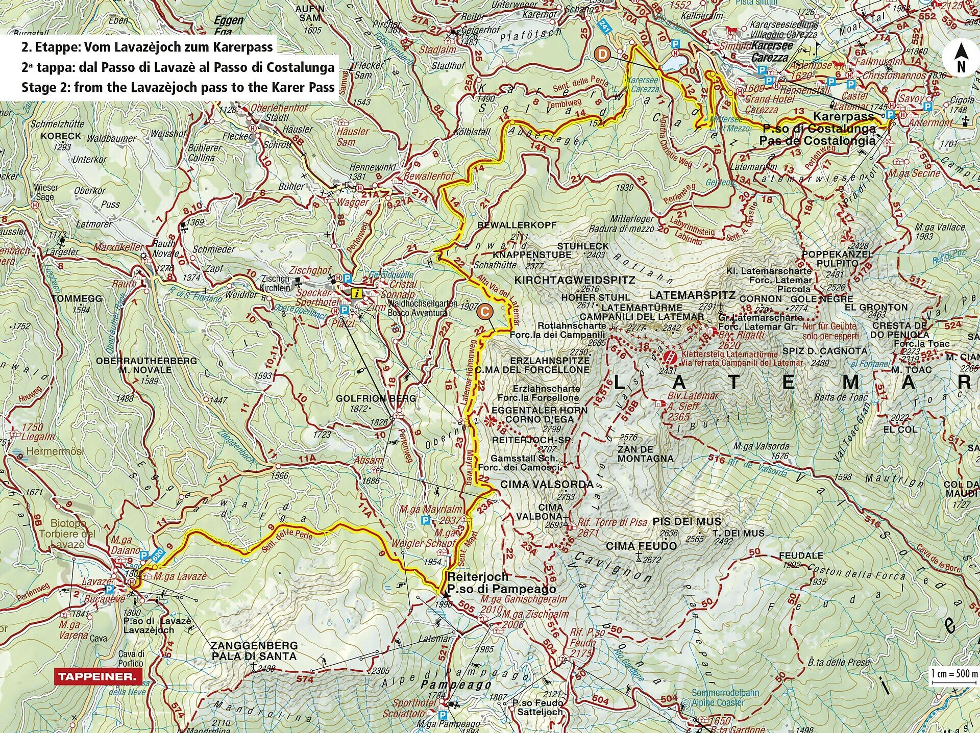
From Lavazèjoch, follow about 400 meters along the state road towards Rauth (north). Opposite the signpost "Lavazè" turn left onto path [9] (Pearl Path) towards Reiterjoch. This leads gently uphill through the forest to Reiterjoch (Passo di Pampeago).
At Reiterjoch, continue left on the Pearl Path and across the road to the next fork. Here follow the right path [23] towards Mayrl Alm. Shortly before the alm, path [23A] branches off to the right. Follow the natural road until before a right curve path [22] branches off to the left.
Path [22] runs along the foot of Latemar through impressive landscapes and past several path intersections, where you always stay on path [22]. Finally, you reach the large scree basin below Erzlahnscharte (Geostop C).
After a short descent, you reach a forest road, which you continue to follow on path [22] through open forest. After merging onto a natural road, take path [21A] on the left. Follow this to the next intersection, then right on path [9], then on [8] (Templ path) towards Karer Lake (Geostop D).
After a short stretch on the lake circular path, turn right at the fork onto path [12]. This leads to Mitterseeweg, where you turn right again on [12] around the small Mittersee. At the end, follow the natural road to the main road to Karer Pass.
At the last junction, go left, then right onto path [13], which becomes path [21] – this leads directly up to Karer Pass, the stage destination.
The starting point of the route is easily and conveniently accessible by public transport.
By public bus line:
- 180 or 181 from Bolzano
- 180 or 184 from Karersee, Karer Pass, Welschnofen
184 from Birchabruck, Stenk, Eggen, Obereggen, Jochgrimm
- 184 from Weissenstein, Petersberg, Deutschnofen
- 182 from Steinegg, Gummer
-180 from Fassatal
Stop: Lavazèjoch; online timetable search at Südtirol Mobil: www.suedtirolmobil.info
Meeting point: Lavazèjoch: https://goo.gl/maps/oe2Pnprs3RWaX1Xh7
By car:
Destination: Lavazèjoch
Parking: Lavazè parking lot
Meeting point: Lavazèjoch: https://goo.gl/maps/oe2Pnprs3RWaX1Xh7
Starting point: Lavazèjoch (https://goo.gl/maps/h7wC4Yzs2dZFQqXh7)


Here you will find all important information on skipasses, daily, multi-day, and seasonal tickets at a glance. All ski passes can be purchased quickly and conveniently online. Buy your skipass directly from home and get a 5% discount!